

Appleby History > In Focus > 19 - 1841 Census Part 1
Chapter 19
The Appleby Census of 1841
Part 1 - Appleby Parva, Leicestershire
by Richard Dunmore
The first official census in this country took place in 1801 and, with the exception of 1941, every 10 years thereafter. The population figures for Appleby from 1801 to 1951 with the numbers accredited to each county were given in In Focus 17, my account of the growth of Appleby’s population (1).
In the early censuses, where there were small numbers of houses of one county situated within the other, they were included with the majority. As we shall see, the returns show that this was done in 1841 without any correction (2). By 1891, the Leicestershire enumerator recorded how many Derbyshire people he had recorded and the Derbyshire enumerator similarly noted the Leicestershire people in his area (3).
The 1841 Census Returns and the 1831/32 Reference and Map
The 1841 enumerators, one of whom was Edwin Hague the English master of the school, worked their way round the village in a methodical way so that it is possible to deduce where many of the villagers lived (4).
The crucial factor which makes this possible is the near-contemporary 1832 Parish map with its 1831 Reference (5). Importantly the 1831 ‘Owners’ are named. Moreover, in the left hand margin are pencilled further names which must be those of the tenants or occupiers at an unspecified date after 1831 and possibly closer to 1841. Although in the 10-year interval there will have been some changes of occupation of the houses, and indeed in the housing stock itself, many families may be expected to have occupied the same property throughout. This is particularly true of the more stable members of society, eg farmers, owner-occupiers and many of the tradesmen. By contrast it may not be possible to locate precisely those on the move, such as young people who set up home between the two dates, or rent-payers moving a short distance to better accommodation.
The problem of changes in the housing stock is particularly apparent at Appleby Parva, where houses were demolished and New Road built in the 1830s. The 1831 Reference has been manually amended by crossing out properties near the Hall which were demolished at this time. Unfortunately, the previous occupiers are not given. In other areas, new houses were erected. For example the blocks of houses at Little Wigston, well occupied in 1841, were incomplete in 1831/32. Changes were also afoot in Church Street and Top Street.
It is clearly impossible in these articles to comment on all 1075 people recorded as living in the village in 1841, but area by area I can indicate the names of householders whose whereabouts is certain. The best we can say about the others listed near them is that they probably resided in a particular neighbouring property.
Presentation of the Information
Presenting the information on householders following a sequential route around the village is not completely compatible with the sequence in which the Census was recorded, no doubt because the enumerator criss-crossed between houses and cottages as he found people in. However the sequence is sufficiently close for anyone with the Census returns to follow.
Most of the numbered properties listed in this article, especially around the centre of Appleby Parva, are shown on the map below which is based on the 1832 map. Details of each property are given like this: [231,6c,Thomas Grundy]. This means property No. 231, consisting of 6 cottages owned by Thomas Grundy. Because Squire George Moore owned so many properties his name will be abbreviated to GM as in [247, 2c, GM]. The other abbreviations will be:
c = cottage, H = house, FH = farm house, Own = owner-occupier.
Although the owner is given for 1831 it is important to remember that the occupiers of the properties are those recorded in the census of 1841. It should also be noted that the ages of adults were estimated to the nearest five years. The census was carried out on Sunday 6th June 1841, a week after Whitsun. We shall follow the enumerator on his tour around Appleby Parva in Leicestershire (6).
Overtown
The enumerator started his itinerary on Austrey Road, Overtown (Appleby Parva), where Thomas Heafield (aged 65 years), farmer, lived with his family. The 1832 and 1838 maps show his farmhouse half way up the hill on the right (at SK 306 083), near Hoppage Spinney. In 1831 it was owned by George Grundy Esq. and Thomas Heafield whose name is pencilled in the margin was probably the tenant. George Grundy died in January 1832 (7). The farm buildings do not appear on later maps and must have been demolished. The land became part of West Hill Farm.

Click for larger view
Lower down Austrey Road, across fields the from West Hill farmhouse, one of a pair of cottages [247,2c,GM] housed Thomas Mould (62) tailor (see map above). William Wyatt (45) an agricultural labourer (‘ag lab’) was in [239,2c,GM]; and widow Sarah Wood (65) in [238,c,GM]. Ann Boden (40) who was living with Mrs Wood in 1831, probably now had the second cottage of either [247] or [239] leaving the other one empty. All except Mr Mould had family or others living with them.
Nearby and probably across the Atherstone road, lived Joseph Hudson (35), gardener with his wife and family. His cottage is not identifiable but may have been a new one adjacent to the gardens of Appleby Hall, where he must have been employed.
In a cottage [232,c,GM] situated below West Hill Farm lived William Taylor (60), ag lab, and his wife.
Near this cottage was a terrace of six houses [231,6c,Thomas Grundy] and another of four houses [230,4c,Elizabeth Hear]. Mrs Hear owned the Anchor Inn across the road (see below). The enumerator clearly went to and fro between these blocks, the neighbouring cottage [228] and West Hill farmhouse [237]. The most likely occupancies are as follows.
In [231] the householders were Thomas Orton (21) ag lab, John Page (45) ag lab, Sarah Cluloe (60) poor widow, and Robert Boden (45) a malster. Thomas Davenport (65) ag lab was probably also in this block and the sixth house was unoccupied.
Thomas Neal (70) tailor lived in [230]. His neighbours were probably Elizabeth Blood (25) poor widow with a young son and Ann Bowman (37) who had five children. The fourth house was unoccupied.
West Hill farmhouse [237,H,GM] was probably occupied by Edward Langly (40) farmer with his family. A cottage [228,c,Joseph Grundy] situated at the lane end was occupied by Thomas Palmer (40) ag lab and his family. Another cottage across one field to the south [250,c,GM] was occupied by Richard Fish (70) man servant, his wife and family.
The Anchor Inn
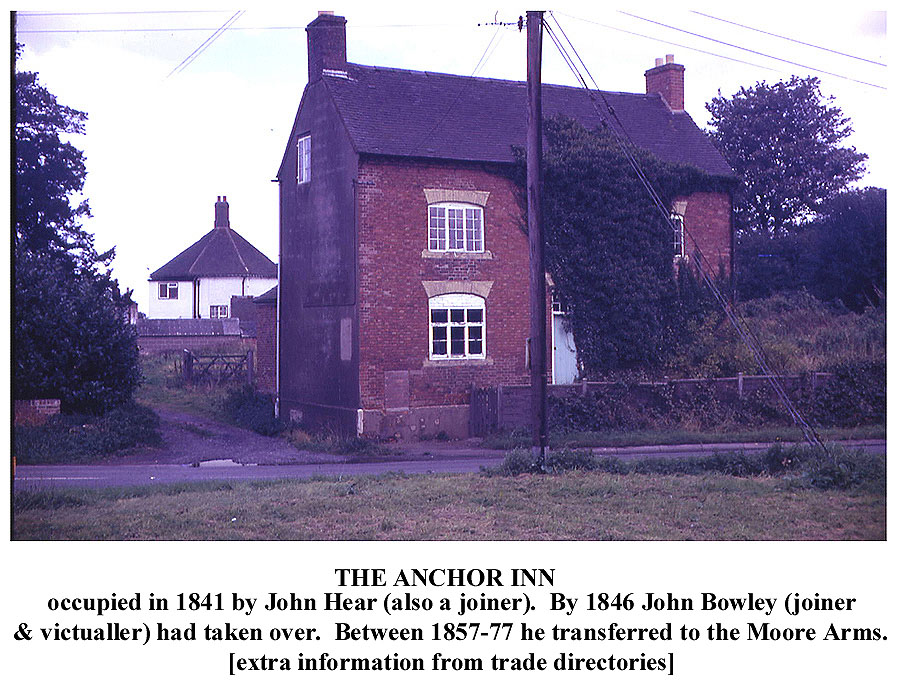 Click for larger view |
Across the Atherstone Road, at the Anchor Inn [253,Anchor Inn, Elizabeth Hear] lived John Hear (60) joiner and his wife Mary (40). Maybe Mary had taken over the Inn when John’s mother Elizabeth Hear, who had owned it previously, died in 1840 (7). Trade Directories show that the licence had been transferred to the Moore’s Arms at some point between the years 1857 and 1877 (8). Near to the Anchor was another house [255,H,GM] occupied by James Arnold (40) farmer with his family.I have marked on the Appleby Parva map the many properties along the ‘Old Road’ near Appleby Hall which were demolished in the 1830s. One cottage at [187,FH+c,GM] which survived until 1841 was occupied by Miss Jane Princep (60) independent and her younger sister Ann, although the farmhouse alongside it had been demolished. The exact circumstances in which the Misses Princep hung on to their cottage while the squire was demolishing all around them can only be imagined.
The bottom of Dingle Lane divided into three arms with several cottages around and between them. William Hear (81) carpenter lived in [227,c,Elizabeth Hear] near the southern arm. Across the lane lived William Fernyhough (40) shoemaker and his wife in [220,c,Own] and William Baker (35) tailor and his family in [219,c,GM]. Just to the north across another arm of the lane stood the cottage [218,c,GM] where William Fisher (40) man servant and his family probably lived.
Across the lane to the west of William Baker was [221,2c, Aldridge] one cottage of which was occupied by John Pain or Payne (50) ag lab. The householder of the other was probably Mary Boden (48) poor widow; living with her were her two daughters and the family of John Dymock (24) man servant. Further back along Dingle Lane at [222,c,GM] lived John Smith (52) ag lab, his wife and sons including Thomas (22) man servant.
On a small ‘island’ of Derbyshire, stood a house [216,H,Own] occupied by Mrs Catherine Grundy (45), independent. She also owned the cottages next door [217,3c,Mrs Grundy] which were in Leicestershire. One was occupied by George Jordan (40) baker, his wife and son. The other two cottages were unoccupied. This area is now the car park of the Appleby Inn.
|
Part of the property [215,FH,John Moore] where Thomas Merriman (35) farmer, his family and two servants lived was also in Derbyshire. Later the Moore Arms, it is now the Appleby Inn. |
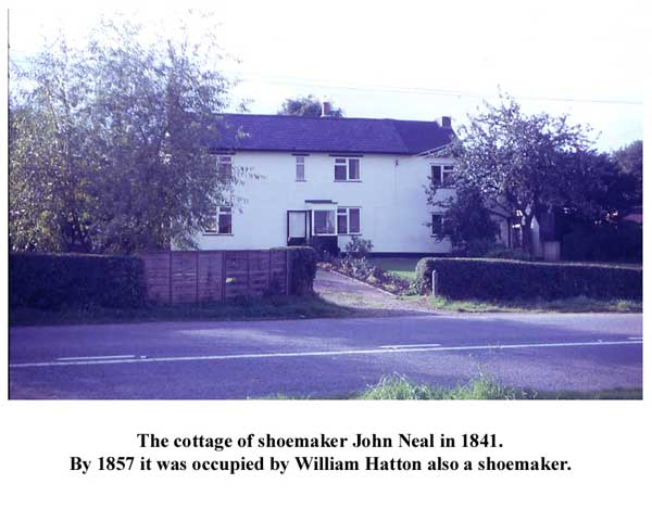
The cottage next door [212,c,John Moore] was occupied by John Neal (60) shoe maker and his family. |
The surgery [209,H,John Mayow] was occupied by Peter Cooper (25) surgeon with a servant. His memorial by the steps to Appleby church belfry shows that Peter Cooper M.D. died aged 41 in 1854. |


Across the Atherstone Road, on the corner of the ‘Old Road’ stood a block of cottages [188,3c,GM]. Two of these were occupied by William Stanton (45) butcher and family and John Dymock (50) ag lab with his wife and three children. The third probably housed George May (20) tailor who lived alone.
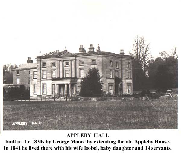
Appleby Hall
Squire George Moore (1811-71) created Appleby Hall in the 1830s by enlarging Appleby House [259,H,GM]. The Hall needed grand surroundings which meant the ruthless removal of the old farmhouses, other houses and cottages along the ‘Old Road’ which were in the way, the culverting of the stream which flowed alongside it, the exclusion of local traffic by building New Road and the construction of a new driveway and gatehouse or lodge.
 Click for larger view |
The extent of the demolition of dwellings and associated buildings can be seen from the map above. These were [182,4c], [184,FH], [185,H], [186,5c], [187,FH], [254,c], [256,H], [257,2c], [262,2c] and [265,2c] with a butcher’s shop. In all 2 farmhouses, 2 houses, 16 cottages and all their outbuildings, yards, crofts and gardens were levelled. It is said that the bricks were reused in the construction of the culvert which takes the stream (originating on the hill at Hoppage) right through the Hall grounds from alongside Austrey Road to the end of Church Street.
Click for larger view |
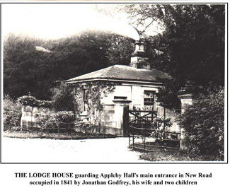 The new Lodge or Gatehouse on New Road was constructed in this period and in 1841 it was occupied by Jonathan Godfrey (30) ag lab, his wife and two children. At Appleby Hall were George Moore (25) independent his wife Isabel (25), their baby daughter and 14 servants.
Over Street (New Road / Top Street)
On an island of Derbyshire, which included part of the School, was a farm house [266,FH,GM] occupied by William Stevenson (45) farmer with his wife and family. The demolition of the adjacent pairs of cottages [262] and [265] made redevelopment of the Hall Farm buildings possible, as well as improving the Hall approach. Also on this Derbyshire island were the cottage [272,c,GM] with blacksmith’s shop, inhabited by James Wyatt (30) blacksmith and his wife; and the adjoining cottage [271,c, School Governors] occupied by Mary Brown (35) and Matilda (15) dressmaker. Henry Brown, who died in 1840, occupied [272] with its smithy in 1831 (7).
 Click for larger view |
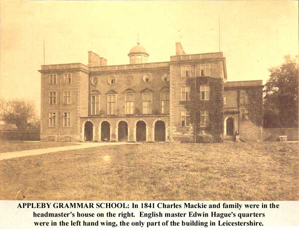
Moving off my map, the next property was Appleby Grammar School [274,2H] recorded as two households both in Leicestershire, although the headmaster’s house was strictly in the Derbyshire ‘island’. The headmaster’s house contained Charles Mackie (40) Head Master with his wife, 3 children and two servants, a boy and a girl both aged 15 years. The English Master Edwin Hague (40) lived in the English Master’s house with his wife, young son and a servant girl. No boarders were at the school, possibly because on the Sunday after Whitsun the boys were still on holiday.
Continuing along Over (Top) Street, at the NE corner of the School grounds stood a cottage [275,c,Bosworth School] occupied by Mary Proudman (80) poor widow with John Proudman (60). This cottage was demolished by 1861 to make way for a new pedestrian entrance for the elementary school for village boys (9). Next was a house, now Bateman House, [283,H,Own] where Bateman Saddington (65) farmer lived with his wife Elizabeth. Samuel Saddington (32) butcher also lived there with his wife and young family; as did John Insley (50) ag lab and two servants.
Next came three cottages [285,3c,Thomas Garner] (probably now 83/85 Top Street). One was empty and the others occupied respectively by Thomas Wright (34) ag lab and his family; and Thomas Taylor (30) bricklayer with his family. Also living with the Taylors were William Foster (22) draper and a servant girl. The next cottage [286,c,GM] was occupied by John Saddington (34) butcher and his family.
The next property was the Particular Baptist Chapel at Brooks End. In the next article, starting at the chapel, I shall trace the remainder of the Leicestershire enumerator’s route, through the south-eastern part of Appleby Magna.
Notes and References
1. The division of the village between Leicestershire and Derbyshire complicated the census enumerator’s task. This led to errors in the two partial counts although the total for the whole village was more or less accurate. Although by 1901 the parish had been united in Leicestershire, the former Leicestershire part of the parish was still in the Western or Bosworth Parliamentary Division of Leicestershire whilst the former Derbyshire part was still in the Southern Division of Derbyshire. Edwin Farmer the enumerator gives a detailed description of each part, by street and property (see APPENDIX) showing that the division of the parish shown on the 1838 map survived unaltered right up to unification in 1897.
2. In particular streets, the inclusion of minority groups of one county within the count for the other county appears to have been done for the convenience of the enumerators. The areas affected include parts of Church Street, Top Street, Duck Lake and the school. No correction was made for these exchanges in the separate counts recorded in 1841, so although the total for the village is accurate, the partial totals for the two counties are not.
3. In 1891, the ‘Leicestershire’ enumerator Edwin Farmer recorded 379 people, of whom 154 were living in Derbyshire. The ‘Derbyshire’ enumerator Edmund Tunnadine recorded 278 people, of whom 59 were living in Leicestershire. The potential for error was high unless the enumerators co-operated very carefully. The 1821 figure was said (in 1831) to have been erroneously high and examination of the 1851 returns shows that the division of the counties was different from 1841.
4. Edwin Hague (Appleby School Writing master 1816-38, English master 1838-61) was the enumerator of the Derbyshire part: ‘witness my hand this 12th day of June 1841, Edwin Hague, Enumerator ...’ I have no note of the name of the enumerator for the Leicestershire part, but the Appleby Grammar School page, which is the last page of the Appleby Leicestershire returns, was signed by Charles Mackie, Headmaster.
5. Map of the Parish of Great and Little Appleby in the counties of Leicester and Derby, 1832 and Reference to the Map of the Parish of Great and Little Appleby in the Counties of Derby and Leicester, 1831, Trustees of the Sir J Moore Foundation.
The Map is at a scale of 8 inches to the mile and the Reference section numbers a total of 988 ‘Premises’ which the parish comprised ranging from houses, cottages and buildings to closes (agricultural fields), orchards, yards and gardens. Many of the fields are named. The premises each have a brief description (‘Kind’) which is usually meadow, pasture or arable. The ‘Quantity’ or size of each is given in Acres, Roods (1/4 acre) and Perches (1/40 acre). The total area of the parish in the survey was 2803 acres and 3 roods, including some 42 acres of ‘Roads and Waste &c &c’.
6. Because of the size of the documents and the work involved in producing an accurate transcription, it is impracticable to reproduce the census returns in full here. I consulted the Leicestershire part at the Leicestershire Record Office and the Derbyshire part at Burton on Trent Library.
7. Appleby Burial Registers: George Grundy 27 Jan 1832 aged 78; Elizabeth Hear June 22 1840 aged 85; Henry Brown 19 Nov 1840, aged 70
8. White’s Directories of Derbyshire 1857, and Leicestershire & Rutland 1877
9. R Dunmore, This Noble Foundation, Sir John Moore Foundation, 1992, p 53
©Richard Dunmore, May 2003
APPENDIX
CONTENTS OF ENUMERATION DISTRICT OF APPLEBY MAGNA
extracted from 1901 Census
Note: Explanatory words have been added thus [in square brackets]
Enumerator, Mr. E Farmer Appleby Magna
Civil Parish of Appleby Magna (entire) in the Rural District of Ashby de la Zouch
Parliamentary Division of the Western or Bosworth Div. of Leicestershire (Part of)
also of the Southern Division of Derbyshire (Part of).
Western or Bosworth Division of Leicestershire (Part of)
Comprising that part of the Civil Parish of the Parish formerly in the County of Leicester, including Appleby Hall, the whole of Overtown [Appleby Parva] Moores Arms Inn, West Hill Farm, Keepers Cottages, Rectory Farms, Barnsheath Farm & 2 cottages, Mill Cottage, 3 houses on Snareston Road, Botts Lane 2 houses, Part of Grammar School & Riley’s House, Rushes Cottage, (Brook End), 4 Chapel Houses, & Chapel & Chapel adjoining, House occupied by Saddington, 4 Cottages [occupied] by W Boss, Garner & void, 4 cottages [occupied] by A Boss, Harding and Haywood, Overstreet, 12 houses, The Beeches, Church Street, 7 Houses from Tunnadines to Queen Adelaide Inn inclusive, one House occupied by Rice, Post Office, 5 Almshouses, Moat Cottages, Ducklake, 2 Houses occupied by G Wyatt, & Thomas Parker (Farm House) also 3 Cottages in old end occupied by Kendall, C Gothard, & H Gothard, also Dingle Cottage.
Southern Division of Derbyshire (Part of)
Comprising that part of the Civil Parish (Formerly in the County of Derby) including (Part of Grammar School, [Headmaster] Menneer’s House) 2 Houses occupied by Farmer & Woodward, Snareston Road 2 Houses [occupied] by Camp & Sutton, Botts Lane, 4 Houses [occupied] by Caldercot, Clamp, Bott & Marshall, Brook End 1 House [occupied] by H Kelsey, Part of Overstreet 6 Houses [occupied] by Jordan, Beadman, G Jewell, Yardley & Warrens & Boss, the whole of Black Horse Hill & Mawbys Lane, Duck Lane or old end 6 Houses [occupied] by Edge, E Gothard, & 4 void, Ducklake, all but 2 Houses [occupied] by G Wyatt & Thos Parker, all Bowleys Lane, Wigston, Appleby Field Farm, Appleby Rectory, Heath House, Manor House, 2 White House Cottages, Birds Hill, Side Hollows Farm, Measham Road 2 Houses, Golden Way [Rectory Lane], Dovecote House, Church Street, 10 Houses [occupied] by Bates, Starbuck, Bowley, Williams, Webster, Preston, Orton, Coulton, Church Street, 6 others including, Crown Inn, Parkers, Smout’s, Winter, Jordan, & Bowley also 3 houses in Stony Lane.
Previous article < Appleby's History In Focus > Next article
May 2011: With the availability of enhanced technology since this article was first published, it has now been possible to create a full transcription of the 1841 census. Transcripts of Appleby censuses 1841 to 1911 are available here