

Appleby History > In Focus > 1 - Beginnings
Chapter 1
Beginnings
by Richard Dunmore
Archaeological evidence suggests human activity in the area around Appleby Magna from the early Neolithic period, ie up to 6000 years ago. This was when settled farming - rearing animals and cultivating crops - began to replace hunter-gathering as the principal means of providing food. Arable cultivation had its primitive beginnings as woodland was progressively cleared, but hunter-gathering was still vital. The picture that emerges from local archaeology is of the gradual development of small settlements from the Neolithic period onwards. There is no suggestion of a nuclear settlement (ie central village) until Saxon times. Rather, scattered farms or small groups of farms with their characteristic thatched round-houses and associated buildings were built on the gentle slopes south of the River Mease. Each group was protected within its defences and surrounded by a system of fields as clearings were carved out of the ancient forest.

Click image for larger view
The site of the earliest known human activity in the parish was discovered on Barns Heath Farm (SK330 098) by aerial photography. An oval shaped enclosure about 2.5 hectares in area (about 220m by 145m) and distinguished by three concentric ditches showed up as crop marks. This configuration is early Neolithic in character and a subsequent archaeological excavation c.1966 produced prehistoric pottery. In a review of Neolithic and Bronze Age Leicestershire, Patrick Clay compared the Appleby site with a better preserved early Neolithic ‘causwayed enclosure’ at Husbands Bosworth in the south of the county. Although the photograph of the Barns Heath site showed no entrance causeway, these multiple ditched systems are both interpreted as settlements or central meeting places (1) (2).
Elsewhere in the parish crop marks also disclosed a rectangular enclosure a short distance east of the White House (SK326 108) which is a possible Iron Age site. Further crop marks of a ring ditch, possibly Bronze Age, with another unidentified ditch have been noted on Birdshill Gorse (SK314 118) (3). The sites are marked on the following map of the parish.
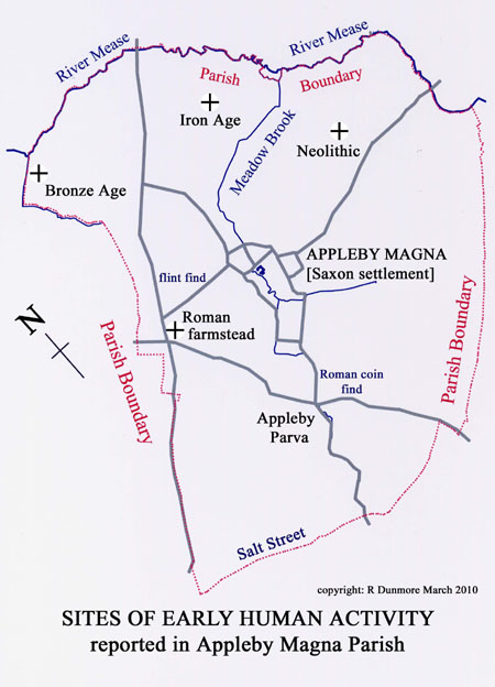
It is notable that these early ‘settlements’ are all above the flood plain but within a few hundred metres of water, either the River Mease or its tributary the Meadow Brook flowing down from Appleby Magna, the village which developed by the brook in Saxon times. Early field systems, for crops and animals, were developed in woodland clearings at other locations and they must have been developed here too, although no evidence of them has been found.
John Nichols writing in the early 19th century reported: ‘Some remains of urns with ashes have been found, in getting gravel in this parish’ (4). These undated finds are thought to have been made on one of the higher areas of the parish, such as the Salt Street ridge, where gravel deposits occur (5). Pieces of flint hand-tools found on the allotments (SK312 102) in 1989/90 are typical evidence of skilled activity in prehistoric times. The smallest of these flints was examined by Peter Liddle of the Leicestershire Museums Identification Service in 1989: ‘This appears to be a core trimming flake. One edge is damaged, but the other appears to be retouched, probably as a scraper’ (6).

Click image for larger view
Salt Street, the lane on Appleby’s south-western boundary, and marking the county boundary with Warwickshire, may itself be a very ancient trackway, Roman or earlier, running along the hilltop. Until recently, few Roman remains had been found locally, one exception being a single coin found at Appleby Hall Gardens (SK310 087). Nichols has suggested that nearby Stretton-en-le-Field, a little further down the Mease valley, derives its name from a Roman ‘street’ as do other villages called Stretton (7). The problem is that there is no obvious Roman road to which this might refer. Salt Street which is 2 miles (3.5 km) away from Stretton is an unlikely candidate. No evidence of a Roman villa has been found in the area either.
However, the recent discovery of a late 4th century Romano-British farmstead on the site of the new motel (near the motorway junction) shows that the Romans were active in the locality. Timber buildings were revealed by post holes and Roman coins and pottery of the period provided the dating evidence. The Roman Occupation is discussed more fully in the following chapter. Intriguingly, the farmstead excavations also showed signs of early Anglo-Saxon presence - 'sunken featured buildings' (known in northern Europe as Grubenhäuser) typical of the 5th and 6th century Saxon settlements. So within the parish archaeological evidence has been found of human habitation from the earliest agricultural settlements of the Neolithic period right through to the early Saxon period. There is however no evidence of continuous occupation until the present village of Appleby Magna was established near the village brook later in the middle Anglo-Saxon period (8).
Notes
1. P. Clay, The Neolithic and Bronze Age of Leicestershire and Rutland, TLAHS, 73, 7, 1999. Other recent papers on prehistoric Leicestershire may be found in the Transactions of the Leicestershire Archaeological and Historical Society. On Iron Age sites: M. Beamish (72, 1998) and P. Clay (66,1992); on Iron Age and Romano-British enclosures at Normanton le Heath: R Thorpe, J Sharman & P. Clay (68,1994)
2. M Beamish, The First Farming Communities, in Leicestershire Landscapes, Leicestershire Museums Archaeological Fieldwork Group, 2004, 33-35 (early Neolithic sites)
3. P. Liddle, Leicestershire Sites and Monuments Record Index, 1985
4. J. Nichols, History & Antiquities of Leicestershire, IV, pt 2, 1811, 432 (burial urns)
5. Geological Survey of Great Britain, Sheet 155, Atherstone, 1953
6. P. Liddle, Archaeological Report to Author, 1989
7. J. Nichols, op. cit., III, pt 2, 1804, 1024 (place name Stretton-en-le-Field)
8. For studies of the origin of villages and their field systems see: Trevor Rowley, Villages in the Landscape and Christopher Taylor, Fields in the English Landscape, both published by Alan Sutton, 1987
Approximate British Chronology
- Neolithic: 4000 to 2000 BC;
- Bronze Age: 2000 - 800 BC;
- Iron Age: 800 BC - AD 43;
- Roman: AD 43 - AD 410
© Richard Dunmore May 2000, revised March 2010
Previous article < Appleby's History In Focus > Next article