
Appleby History > In Focus > 9 - Medieval Open Fields
Chapter 9
Identifying Appleby's Medieval Open Fields - Part 1
by Richard Dunmore
The Open Field System
Open fields comprised usually two or three large un-enclosed areas of land surrounding the village settlement. These were mostly arable - for the cultivation of crops - but there were also areas of meadow, pasture and waste or heath. The meadows were often alongside streams and the heath-land occupied the uplands on the margins of the parish. The arable land was divided into a large number of strips, known locally in the Midlands as lands - see note (1). Remains of groups of these survive as ‘ridge and furrow’, the familiar undulating pastures still evident around the parish. A good example is on the ‘Flatts’, the field crossed by the footpath between Top Street and Church Street near the school. The word flatt itself is Old Norse and synonymous with furlong meaning a group of lands (see below).
The holding of any particular farmer or peasant consisted of a large number of these lands scattered across the fields. The lands were individually tenanted but farmed under a communally agreed plan of cultivation. The farmer’s livestock was allowed on to the meadowland and arable lands after harvesting was complete. Heath and common were also used for grazing under further local rules and all these rules were laid down by a formal meeting of the farmers at the manorial court or at a special village meeting (2). In a 15th century glebe terrier of Appleby’s lands (see below), in the ‘Feeld nygh Norton’ the rectory was said to hold four lands ‘at Spellow’. The meaning of this term appears to be a ‘moot’ site or meeting place - literally a story telling (OE spel-) hillock (hoe) - and just the sort of place for the assembly which would have determined the bye-laws which governed the management of the fields in Saxon times (3).
These rules would have included the sequence of rotation and it is important to recognise that the unit of rotation was not the open field, but its sub-division the furlong, comprising a large block of lands occupying about ten acres (see In Focus 5). This enabled a great flexibility in the rotation system used (4). As populations grew, cultivation areas expanded towards the parish limits and available grazing on marginal heath-land shrank under this advance. In these circumstances, strict control of the various communal farming activities was essential. Clearly the farming situation was never static for long but adaptation was possible within the framework of the open fields. New fields could be created, but the flexibility for changing or adjusting crop areas lay with the furlong.
Appleby developed as a nuclear settlement in the period before the Danes arrived in the ninth century; and the village would have already been surrounded by field strips. The concentration of housing in a nuclear village and the development of the fields went hand in hand (5)(6).
By the date that Burton Abbey acquired its land at Appleby Magna in AD 1004, a primitive system of strip fields would have existed. This system evolved over several hundred years and expanded to serve the needs of the growing population. Development continued under the Abbey’s management and, of the unusually large number of eight open fields which developed here, five may be attributable to the Abbey’s activities.
The Evidence for Appleby’s Eight Fields
Much of the parish, perhaps 1200 acres, was enclosed down the centuries in a piecemeal fashion by local agreement, breaking up the large expanses of the open fields. However, the final and largest enclosure took place in the late 18th century following the Appleby Enclosure Act (1771) and Award (1772), which authorised the enclosure of more than 1650 acres of the remaining open fields and commons (7). However the map which originally accompanied the Award has been lost. The loss of the map means that we no longer have a plan of the open-fields and furlongs before the 18th century enclosures.
After 1772, the countryside was divided up into new enclosures - our modern fields - but many of the names of the old furlongs were adopted for these new fields; so the names persisted for many more years near their original locations.
Using Glebe Terriers - records of the land holdings of the parish church - the problem of the map loss has been overcome to a large extent. The terriers give the contemporary names of the pre-enclosure open fields; and the location of the church lands is described within each of them by reference to named furlongs. By comparing furlong names with the later field-names, I have been able to establish the approximate location and number of the open fields and reconstruct the map. It is now clear that there must have been eight open fields in the parish.
The open fields have been examined in Glebe Terriers for four particular dates: 15th century which is listed by John Nichols (8); and 1606 (9), 1638 (10) and 1679 (11) which all survive in Record Office depositories. Where the names of the open fields differ between years, identification has been made possible by reference to the furlong names of the lands listed within them. Although names of the furlongs were available in only two of the four terriers, C15 & 1638, identification of the fields was quite clear.
THE EIGHT OPEN FIELDS OF APPLEBY MAGNA
as they were listed at the stated dates
C15 |
1606 |
1638 |
1679 |
1. campo juxta Snareston |
4. feild towards Snarson |
4. field toward Snarson |
5. towards Snaston |
2. Le Cleyfeld juxta Bigging |
3. middle clea feild |
3. middle clay field toward Stretton |
4. towards Streeton |
3. Le Heith Feld |
5. Bridge Hill feild |
5. Bridghill field |
[absent] |
4. Le Feeld nigh Norton |
[absent] |
[absent] |
[absent] |
|
6. fish marle pit feild |
6. fishmarlepit field |
6. Fishmarlpit |
6. Le Herth Feld |
7. moore feild |
7. the moorefield |
3. Moor |
7. [absent] |
1. dingle feild |
1. dinglefield |
1. Dingle |
8. [absent] |
2. Medow Brooke feild |
2. meadowbrooke field |
2. Meadow |
 Click for larger view |
It should be emphasised that the names of the fields are given only because the rectory held lands in them at those particular dates. Hence the absence of an open field from any one list may be due to the rectory not holding land in that field at that time. Many agencies were at work. A field may have lain fallow that year, although that seems unlikely for the larger fields. Another possibility, especially in earlier centuries, is that the land had not yet been won from the heath. A decline in population, such occurred during the Black Death in the 14th century, must have resulted in areas of land being taken out of cultivation or at least being reorganised. Again, in later times, a powerful landowner may have managed to accumulate large areas for enclosure in one or two particular fields to the exclusion of other farmers.
Following my last article on the land of Burton Abbey, I shall begin with the north-western, Derbyshire, side of the parish where the land of the Abbey lay.
The Two Clay Fields
In the 15th century terrier, these two fields are listed as Le Cleyfeld juxta Bigging and simply Le Cleyfeld. The word Bigging appears to have been a medieval term for a building (12), so it was the ‘Clayfield next to the Building’. Whether this was referring to a particular building - perhaps the Abbey’s farm buildings - is uncertain, but its location was close to the village on the western side, where the Abbey’s farmstead is likely to have been. In the later terriers, its name changed and mutated: The Middle Clayfield (1606) became The Middle Clayfield towards Stretton (1638) which in turn shortened to the Field towards Stretton (1679).
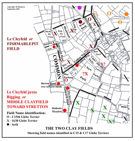 Click for larger view |
Le Cleyfeld was listed separately in the 15th century terrier and was clearly regarded as a distinct field. Throughout the 17th century known as Fishmarlpit Field, it lay to the north of the other Clay Field. The field-pond alongside the Appleby to Stretton footpath at SK 313105 is almost certainly the surviving ‘Fishmarl’ pit.
The acquisition of land here by Burton abbey in AD 1004 would have speeded development of cultivation on the north-west side of the parish. Both Clay Fields stretched out westwards to the parish boundary. Along this length, the boundary is close to the village and traverses several right-angle corners where the furlongs of Appleby and Stretton parishes interlocked. This indentation is evidence that cultivation reached this area from both villages at an early date (13). I have noted that Appleby and its neighbours appear to have been carved out of a Saxon ‘multiple estate’ (14). The line of the boundary was clearly defined by the competing areas of cultivation approaching from each side. On the Appleby side, one of these boundary furlongs was ‘Dullocks Meadow’, identified by name in terriers in the Clay Field towards Stretton, and located by the name of a post-enclosure field opposite Little Wigston (15). Appendix 1 compares relevant field names for the two Clay Fields.
In the 1638 Terrier, The Middle Clayfield towards Stretton contains references to the new parkeand the farm parke. The area of land between Rectory Lane and Mawbys Lane contains the fields Upper Parks and Lower Parks. It seems likely that this area was enclosed in the early 17th century after it had been acquired by the Dixies of Market Bosworth. The irregular shapes of some of the modern close boundaries testify to early enclosure. Later it was ready-made park-land to grace the environs of the Rectory built c.1807 (16), having been conveniently acquired by the Rector in the Enclosure Award of 1772. Golden Way, now Rectory Lane, is referred to in both Clay Fields and must therefore have been the boundary between them. Other boundary positions have been established in a similar way.
There appear to have been areas of land reserved as Common land which served one or two open fields. One of these lay on the west (Stretton) side of the Tamworth Road; and to the north of Burton Road and Dullocks Meadow (17). Hay-/ Ay-, identified with Hay Furlong, occurs in both Clay Fields and must have lain near their mutual border. The word hay here probably means hedge, ie the boundary hedge between the arable land and the common. It is on Hay Furlong that the site of a small late-Roman farm was recently found (18). Clearly this part of the parish has been in cultivation, if not necessarily continuously, for a very long time.
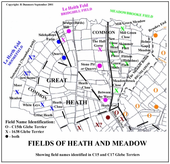
The Meadowbrooke Field and the Two Heath Fields
 Click for larger view |
Burton Abbey’s land stretched northwards from the Clay Fields towards the Great Heath on Birds Hill. One open field was developed alongside the Meadow Brook where it flows away from the village to the east; and two more on the fringes of the heath. As with the Clay Fields areas of common land were set aside from the arable or meadow lands.
There is evidence in the field names from the Meadowbrooke Field to show that its cultivation goes back at least to the period of the Danish settlement. Several Scandinavian name elements are concentrated here: Holme Gap, Skimmer/Skunnier Flatt and Flittem/ fflitholme Flatt. This area is bordered by the Meadow Brook and, to the north, by the River Mease into which it flows. Invading Danish forces are thought to have penetrated the area following the main rivers and streams and this would be a natural point of arrival and first settlement at the bottom of Appleby’s shallow valley. The land itself would be particularly fertile. An area of common land to the north of part of this field would have been at the bottom of the hill near the river adjoining the common of the next field at Bird’s Hill. Despite the antiquities of its field-names, this small field was absent from the C15th Terrier. Maybe it was out of use or lying fallow at that time. Appendix 2 compares relevant field names for Meadowbrooke Field.
Le Heith Feld or Bridghill Field lay to the west of Meadowbrooke Field and stretched from the edge of the village at Heath End to Birds Hill - a corruption of Bridge Hill - and Sidehollows. This field contained the Abbotts Hey, which, although unidentified in precise location, is a positive indication of one-time ownership by Burton Abbey. It was probably the boundary hedge (hey or hay, see above) of the Abbot’s land with the heath. There are various references to gorse, further evidence of the land’s former status as heath and an area of common probably adjoined that of Meadowbrooke Field. Three quarries or stone pits were worked on Bird’s Hill and these are identifiable in the three open fields which lay there.
Le Herth Feld or Moorefield appears to have been a continuing development on the edge of the Great Heath, skirting westwards round the hill alongside the Mease. The 1638 terrier has several references to the footemarch which may be interpreted as a boundary path, probably along the parish boundary at the River Mease. The common lay above the cultivated area under the hill and alongside the heath. It would appear from this, that when the new open field came into cultivation, an adjacent portion of heath was allocated as its common (17). Appendix 3compares relevant field names for the two Heath Fields.
In the second part, I shall look at the remaining Open Fields: Snarestone, Norton and Dingle.
Notes and References
1. From my childhood years in Northamptonshire, I have known the undulating field ridges, preserved in the pastures, by the name londs, a dialect form of the word land. The word headland was also in use in the 1940s to describe the ridge which ran at right angles across the end of the furlong. This was the unploughed baulk where the plough teams had turned.
2. Christopher Taylor, Fields in the English Landscape, Alan Sutton ,1987 , p71 (village meeting)
3. Peter Foss, ‘Market Bosworth and its Region’ in Anglo-Saxon Landscapes in the East Midlands, ed. Jill Bourne, Leicestershire Museums Arts and Records Service, 1996, p89 (‘spellow’)
4. Taylor, op. cit. p 72 (furlong as unit of rotation)
5. Trevor Rowley, Villages in the Landscape, Chap 4 (nuclear settlements and open fields developed hand in hand)
6. Taylor (op. cit. pp 64-66) argues that, prior to their advance into England, the Saxons were not using open-field systems in Europe. Rather, when they arrived in England, they took over successful working farming systems from the Romano-British inhabitants and gradually adapted them to the economic and social conditions of the time. He suggests that open-field systems developed in parallel in England and on the Continent. Rowley (op. cit. p 84) also argues for a ‘considerable degree of continuity in rural areas’ from the late Roman to early Saxon periods. Precisely how the open field systems developed from Roman fields is not yet understood, nor can a precise date be given for the development of the plough, a prerequisite for strip cultivation.
7. My calculations of the areas of land, ie that still in open field or common and that enclosed piecemeal before the parliamentary enclosures, are based on the rectory’s allocations (in lieu of tithes) in the 1772 Enclosure Award (Leicestershire Record Office 15D55/44). The Award states that these areas were ‘equal to one full seventh part of the said Open Fields and Commons as are now subject to tithes and also in full for one tenth part of the present inclosures within the said Parish.’ The rector’s 1/7th part of Appleby’s open fields and commons amounted to 239 acres; and his 1/10th part of ‘ancient inclosure’ amounted to 120 acres. These 1/7th and 1/10th parts were common rates used by the parliamentary commissioners at the time - see W E Tate, The Parish Chest , p 141.
8. Glebe Terrier dated C15 by Royal Commission on Historical MSS, J Nichols, op.cit. p 438 (date information from Alan Roberts gratefully acknowledged)
9. Appleby Glebe Terrier, 1606, Lincoln Record Office (Alan Roberts’ transcription)
10. Appleby Glebe Terrier, 1638, Leicestershire Record Office, 15D55/ 43 (Alan Roberts’ transcription)
11. Appleby Glebe Terrier 1679: W M Beresford, ‘Glebe Terriers & Open Field Leicestershire’, in TLAS XXIV, 1948-49, pp 77-126
12. A D Mills, Dictionary of English Place-Names, OUP, 1991, p 35, 379 (bigging - Middle English, ie AD 1100 to 1500)
13. Taylor, op. cit., p 75 (irregular parish boundaries)
14. In Focus 3 (Anglo-Saxon multiple estate); a short distance to the NW, the boundary of Stretton with Chilcote shows similar erratic diversions around furlongs.
15. The origin of Little Wigston, the hamlet lying near the old crossing of the two main roads (at SK 305099) is obscure. Its name would imply Scandinavian roots (Viking’s tun) and it is tempting to link it to the Danish settlement, but references in literature or maps are scant. Alan Roberts has found Witghiton Close in the early 17th century will of John Wright (LRO wills 1606/83 - see his Appleby web article on the Tudor Parish). This would prove that the name pre-dates, by a long period, the group of nineteenth century brick-workers cottages to which it later became attached.
16. Nichols, op. cit. p 432 (newly built Rectory - now the Old Rectory). Big Job’s Field (SK 311100), to the south of the Old Rectory frontage, has some irregular curved boundaries and a splendid array of ridge and furrow. The park-land ambience is enhanced by the scatter of old horse-chestnut trees.
17. The relative locations of the commons are given in the 1638 Terrier (see Appendices). The terms Common, Heath and Moor all occur in this terrier, often confusingly. Common meant land held and controlled ‘in common’. Heath was applied to larger areas of heathland, not subject to such strict regulation. The Moor seems to have been an area of perhaps waterlogged waste ground on the northern margins of the parish above the Mease.
18. Sophie Clarke, Archaeological Report ‘Appleby Magna, off Rectory Lane (SK 308102)’, in TLAHS, 74, 2000. p 231-2; also full report ULAS Report 99/142 (see this web-site)
©Richard Dunmore, September 2001
Previous article < Appleby's History In Focus > Next article